Our comments re TWC application on Edgmond road, 85 houses.
TWC/ 2012/ 0297
Development on green belt land bordered by Edgmond Road (B5062) Chetwynd Road and Green Lane
Here are Newport History Society’s remarks and objections to the above application.
In this report, when we refer to the fields of the planning application, we shall use the local field names; that is, from the 1842 Tithe Apportionment Map (see CMGS figure 7)
Newport History Society has been in existence for over 30 years and has numerous research publications to its credit. We feel it remiss of the CMGS Consulting not to consult our society or use our publications in their report. Their report states that they should use published and unpublished reports. They have, however, used neither published nor unpublished reports or research of our Society. Equally remiss is not to have consulted the Portable Antiquities Scheme, where a large number of our finds from the area in question been recorded.
We shall also refer to PPS5 throughout – a policy statement prepared by the Dept. for Communities & Local Government, English Heritage and the Dept. for Culture, Media & Sport, published in 2010. – Planning Policy Statement [PPS] 5: Planning for the Historic Environment In March 2012 the government published the National Planning Policy Framework [NPPF] which eventually will replace Planning Policy Statement [PPS] 5. Advised by Katie Foster (ex chair Heritage Lottery West Midlands) and Richard Morrice Policy Dept English Heritage, they concur say that the PPS5 Practice Guide remains valid until replaced. We consider that CMGS should not be referring solely to NPPF but using English Heritage’s advice that: ” the PPS5 Practice Guide remains valid”. ( This was made plain by Katie Foster at the Public Inquiry into the planning application on Station Road site March 2013)
PPS5 states that:
The historic environment is a rich and diverse part of England’s cultural heritage. It takes in all aspects of the environment, as a whole, that have been shaped through human activity. The value of the historic environment, and the contribution it makes to our cultural, social and economic life, is set out in The Government’s Statement on the Historic Environment for England 2010.
It reminds planners that:
the value of the historic environment is recognised by all who have the power to shape it; that Government gives it proper recognition and that it is managed intelligently and in a way that fully realises its contribution to the economic, social and cultural life of the nation.
We shall cite areas of local ‘heritage assets’ that could be lost if this application goes ahead
1. Newport’s water history assets:
We object to the loss of the ancient Newport lake to the west of Chetwynd End.
All Novaportans know that water is a hugely important part of Newport’s past. It is not surprising that the town’s coat of arms is three fishes; that the medieval burgesses were required to supply the king with free fish and that the patron Saint of our church is the patron saint of fishermen.
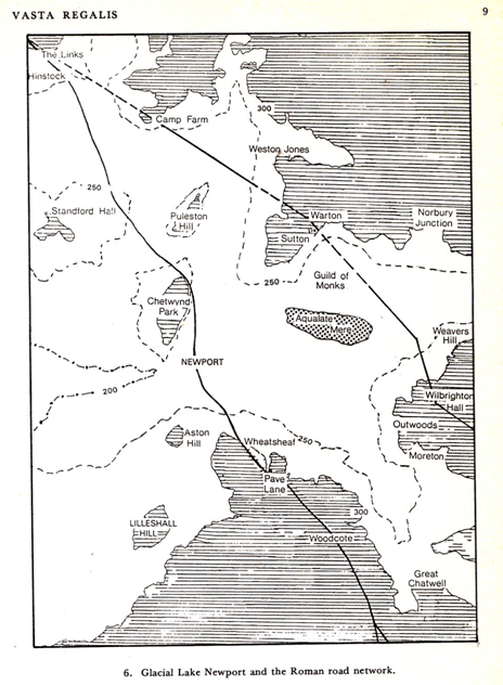
After the last Ice Age, the ‘melt water’ left meandering rivers, marshes and pools in this largely flat area, which became a low and vast lake. Our first settlement is now generally recognised as being called ‘Plæsc’ (the name ‘plæsc’ derives from an Anglo-Saxon word meaning a marshy pool.)1 This early part of Newport’s history is described in the first and second chapters of Prentice’s History of Newport (1986) A shallow lake extended in prehistoric times from beyond Aqualate Mere to the east to Crudgington on the A442 . The name ‘plæsc’ derives from an Anglo-Saxon word meaning a marshy pool.) 2. Plaesc developed in Newport because it was a sandstone outcrop in this watery wilderness, which drew people to a narrow fordable crossing, and, which exited northwards along Chetwynd End and its isthmus now called Green Lane.
The map above is from R Prentice 3and demonstrates the vastness of the glacial lake; that is, the lake that resulted at the end of the last Ice Age. Some of the fields in the planning application are part of that lake.
————————————————————————————-
1. Newport History Society ‘The Saxon Boundary of Newport’ (2008) ( Can be purchased in the Heritage Centre
2. Ibid.
3. Rob Prentice, A History of Newport (1986) Fig 6
=============================================================
Local finds relating this prehistoric lake in the Newport area are:
a. Wall Camp and Kynnesley
3-4 kilometres away is the Wall Camp. The former provides evidence of a multi-vallate Iron Age defended settlement site on an island with Iron Age finds: (HER 01108) and the History Society have recently discovered Roman finds at the Buttery Farm nearby (2013). Interestingly, until 1572 the dead were brought to Edgmond, less than one kilometer from the planned application, by boat for burial from Kynnersley. After this, the Leveson family drained a huge area west of Newport 4
b. Prehistoric log boats:
A Prehistoric log boat was excavated from the River Meese about a mile away at Chetwynd Park and is on display at Harper Adams University College.
Another prehistoric boat was found in the field bordering on Chetwynd End and Edgmond Road( on the corner of 443 ( Cream Stean/ Thistley croft).
A transcript reads reads:
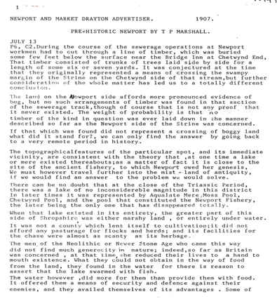
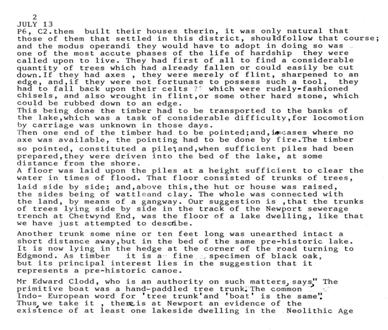
Another trunk some nine or ten feet long was unearthed intact a short distance away . . .in the bed of the same pre-historic lake. It is now lying in the hedge at the corner of the road turning to Edgmond. As timber, it is a fine specimen of black oak; but its principal interest lies in the suggestion that it represents a pre-historic canoe.
TP Marshall, Ed, Newport & Market Drayton Advertiser 13.7.1907
(The full transcribed text of the Article is Appendix B .)
We have received two very recently reports of local people about seeing the boat in the 2nd half of the 20th century – Margaret Bradley and Merlys Jardine – somewhere at the rear of what it now TFM 5. Mrs Margaret Bradley of Edgmond has confirmed that she definitely saw the log boat in the 1970s just beyond the fence of the most easterly field – bordering on Chetwynd End. it was very dark colour and about 8 – 10 ft. long. However, it seems likely that, since Newport was in the middle of a vast lake that ran up to Chetwynd End, there is the possibility that prehistoric boats and a perhaps jetty may be at the Chetwynd End
c. Ancient wells
Today there are springs in the easterly field (443 Cream Stean/ Thistley croft) and in the rear garden of 11 Green Lane. The latter is in fact an ancient well. Dr Margaret Gelling 6 agreed that the pond at 11 Green lane was very likely to be an Anglo-Saxon well. This is some 10 metres from the spring in the easterly field. In the Green Lane isthmus , we believe there to be an impermeable area which allows water to pour out on all sides (possibly limestone or clay?). We suspect that houses put on the south side of the fields by no 11 Green Lane will be permanently waterlogged all the year round as a result of these wells and springs is.
——————————————————————————–
4. www.wellingtonla21.org.uk/discover/pdf/Weald-Moors.pdf
5. Note: These have yet to be followed up L Fletcher 12.05.2013
6. Dr Margaret Gelling of Birmingham University, an expert in Anglo Saxon history, was shown photographs of the well in 1990s by the History Society, as she was helping to to establish the Anglo -Saxon boundaries of Newport.
==============================================================
We need to ask ourselves, what was this area like 10,00- 5,000 years ago or even until the 16th century? It seems highly likely that flat bottomed boats were coming to this area ( ie Meadow 462, Meadow 462, Hunger Hill meadow , Thistley Croft, Green Lane Leasow or Cream Stean.) , when it was a pool and would moor up anywhere at the back of Green Lane or on Chetwynd Road end.
We think that the ‘build up’ of the field on the Edgmond Road sides relates to the creation of the road in more recent times, but the other two sides of the easterly fields cannot be assumed to be modern build up as CMGS suggest. We believe that these meadows have always been substantially lower than the Chetwynd End and Green Lanen and part of the lake.
Because the area looks very different today – although still very wet – we cannot assume that there are no more prehistoric logs boats, jetties or timber trackways to be found. The existence of a prehistoric log boat on the N.E. corner of the fields must require proper excavation at least, but more preferable would be do do a full excavation of the areas Meadow 462, Meadow 462, Thistley Croft, Green Lane Leasow and Cream Stean to assess:
Exactly where the pool went up to
Are there any more boats?
Are there any jetties / landing stages or similar
Are there any votive offerings in the pool?
We shall reiterate that, once these fields are build on there will be no opportunity of ever finding out about Newport’s watery prehistory. If there are prehistoric finds to be made, Telford & Wrekins Planning Dept need to make it happen.
2 Newport’s Anglo-Saxon Boundaries
The History Society object to the potential loss of the Anglo-Saxon boundaries on this site We have been researching the boundaries of Newport (Plæsc), Church Aston and Chetwynd Aston, which are contained in a charter of AD963 and taken the advice and support of Dr Margaret Gelling. (These boundaries of Anglo-Saxon lands are identified not by maps, but by special features of local landscapes, such as roads, trees and brooks – especially water features in the Newport area). We have published our research on this subject : The Saxon Boundary of Newport .
In the area of the planning application, water control features which may be Anglo-Saxon have been tentatively identified: the straw well (‘streawyllan’) and the little dike/ditch (‘litlan dice’). These boundaries are by no means definite, but by building on this research, the definitive identification the northern boundaries of Newport will be found. At the time of our consulting with Dr Margaret Gelling about the landscape features of the northerly boundary, she indicated that the well in the garden of 11 Green lane,which goes over to field 443, was Anglo-Saxon or earlier .The detailed identification of the ancient boundary landscape will be severely hindered once covered by housing.
———————————————————————————————
7. Winchester Cartulary BCS1119. Land given to Wulfric by King Edgar in AD963.
Transcribed by Prof HPR Finberg
8. Newport History Society The Saxon Boundary of Newport , 2008
=================================================
The next section of this report advises the Planning Dept of sites and finds that have not been mentioned in the CMGS Archaeology Report and which are “within the 500m study area due to the proximity of the town of Newport” and may be of significance to the application as a whole
Here are a few that the History Society have noted :
a Two Cock pits. Between 1775-1801 cock fights were held in or at the back of ‘The Green Man & Cock Inn’ in Green Lane 9. There was also a ‘Fighting Cocks Inn’ on the corner of Green Lane 10. This may be the same inn or there may have been two, bearing in mind that Newport had a reported 44 inns. Recent research by a local historian has discovered a cock pit on the Near China Hill Meadow, next to Hunger Hill, and has found gaming pieces and cock spurs plus the distinctive hollow of the pit. 11
b Finds at Near and Far China Hill meadows
CMGS report has omitted to include any Portable Antiquities Scheme finds. A local metal detectorist is the only person to undertake any work in any of these fields but he has found in the Far and Near China Hill Meadows, These are adjacent to the planning application site. The following finds – all medieval have been identified by the Portable Antiquities Scheme : spurs (HESH-370CA6) gaming counters (HESH-363095), tokens (HESH-F9A4E3, HESH-F9BD22, HESH-F9C9F6), lead weights ( HESH-9A0736, HESH-9B0432, HESB-9B2403, HESH-3625F7, HESH-364396), a seal ( HESH-367EB3) and a buckle (HESH-72EA97).
These fields are just two of the local fields adjacent to the planning application. This person was only looking for metal objects. What else could the other fields where the application is sited hold?
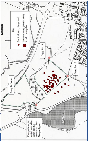
c. Coppice Bank, Chetwynd. This site is opposite the Deer Park pool on the Chetwynd Road Our draft report was prepared in 2012 See appendix A . The most important finds recorded is a the Bronze Age Dagger (the earliest Bronze Age artifacts recorded in Shropshire c 1,500 BC.) but medieval and Roman finds are appearing on the hill and going down to Chetwynd Road ( see map in Appendix A) There is the possibility that this is a barrow site – our finds officer thinks so, and he is in contact with Peter Reavill of the Portable Antiquities Scheme about scheduling this hill as an ancient monument. (The bronze dagger mentioned above now has a Portable Antiquities ref. no. and is HESH-7C7854 )
d. Roman Villa
It is hardly surprising that a Roman villa was found about a mile away in Edgmond at Edgmond Hall – excavated by Christopher Lane in1965 (HER 00795), bearing in mind the road system, which will be discussed below.
—————————————————————————————
9. Victoria County History of Shropshire vol 11 ,1975
10. M Miles, The Inns and Outs of Newport’s Pubs: A History of a Shropshire Market Town, 2007.
11. This has not been reported to the Portable Antiquities Scheme as they were later than 1650 beyond which P.A.S. go.
=========================================================
The last section of this report, shows areas where CMGS have not reported the evidence in its entirety or have been less than fair in their assessment of the evidence; possibly because they did not consult with local historians.
a. Stone Foundations in the fields of the planning application
These were mentioned in CMGS report and are recorded in the Monuments record.
HER 00801 Name: Stone foundations exposed in a trench in 1971
CMGS suggests that these are post-medieval. Stone foundations, however, in Newport, Shropshire, will ALWAYS be the remains of very early buildings; either foundations for timber framed buildings or buildings entirely made of stone. This building is not on any maps (ie it is pre 1842) The fact that only blue and white ware was noticed by the workmen undertaking the pipe work simply indicates that they had no idea of what early pottery looks like; probably thinking that Victorian Willow Pattern was early! These foundations need a full archaeological investigation if the planning application goes ahead.
b. Chetwynd End Significance and Ancient Routes
The Monument record notes that Chetwynd End is post medieval, and that it was built up as a post medieval extension to the town. CMGS have simply copied this out of a very outdated Monument record. Although the Kings Head pub does not have protected status, it has the remnants of a medieval cruck frame (HER 17189). Therefore the building on its own represents medieval activity very close to the fields of the application.
We should remember firstly, that an ancient Roman or earlier road ( London to Chester) passes the planning application site on a north / south axis. This is probably the ‘hehstraete’ (High Street) in AD 963 charter . To the east, there is an ancient ridge way starting at Forton Road, going to Eccleshall and beyond. To the west – now only a foot path to Edgmond called Dark lane – there is another ridgeway over the site at Hunger Hill, then to Edgmond. This was an ancient route from Newport to North Wales.
We have shown that ancient routes north south and east west met in the Chetwynd End area, and it is possible that the site of the Chetwynd weekly market and / or their 3 day fair (instituted 1318) may have been located on or near these cross roads – out of reach of the tolls of nearby Newport. These two route east and west are highly significant and should warrant further investigation of particularly the field that abuts the Chetwynd Road.
SUMMARY
If there are prehistoric finds to be made, Telford & Wrekins Planning Dept need to make it happen. It is so important for Newport’s fledgling tourism offer to fully examine any potential local heritage assets, and water is hugely important to Newport’s history.
It is being blinkered to think that this area has no history. It may not have the world heritage status of Ironbridge but the little heritage assets that we do have should be fully
————————————————————————————————————–
12. op cit, Newport History Society, p9.
================================================================
investigated, recorded and preserved. We suggest that a full archaeological investigation of all the fields should be organised; taking in:
the prehistoric lake site, log boats and possible jetties
the brick kiln in Brick kiln meadow
the stone foundations found in 1971
the extent of Chetwynd End habitation at the easterly edge of these fields
further investigation with Anglo-Saxon experts on the northerly boundaries of Plaesc.
Compiled by Newport History Society: Tavia McLean ( president), Linda Fletcher ( Archivist) Julian Meeson ( Field Activities Officer) and others.
12.05.2013
Appendix A Chetwynd Investigation (Coppice Bank) draft report by J Meeson Field Activities Officer, Newport History Society, 2012
This interim report presents the findings of the metal-detecting and field-walking survey undertaken in February 2009 by the Newport History Society on two fields, Sandy Pit Leasow and Coppy Field. The two fields surround the Coppice Bank which is a conservation area and puts restrictions on the type of survey that can be carried out. Therefore only areas under cultivation could be surveyed. A permissive footpath bisects Coppy field, so for recording purposes the field was referred to as Coppy field A and Coppy field B (see map).
The first field to be surveyed was Coppy field B, this section of Coppy field follows the gradient of the hillside and borders Chetwynd road (the old A41). The field produced a large and varied collection of finds. Two Roman brooches and a number of corroded Roman coins were recovered from the lower slope (bordering Chetwynd road) and appear to date from the latter half of the first century. A small collection of medieval pottery was also found on the lower slope, near the footpath bordering Sandy Pit Leasow, along with a damaged hammered penny dating from the reign of Edward I. However, the majority of the medieval pottery recovered was found on the higher ground where the field levels out, adjacent Coppy field A. A second Edward I penny was also found in this area. The pottery shards appear to date from the mid 13th and 14th century.
A number of military items were also recovered from the lower slope and these consisted of various forms of ammunition and military badges. This was of no surprise to the group as the site has had a long history of use by the military from the Napoleonic wars onwards, until the end of World War II.
Coppy field A is situated above the Coppice Bank and is the smallest of the three areas surveyed. The majority of the medieval pottery was found in this area and dated to the same period as that found in Coppy field B. Over sixty shards of pottery were recovered varying in size and shape and appear to be the remains of cooking pots, storage jars and jugs. This is a significant deposit and indicates human occupation of the site in the 13th and 14th century. A number of medieval coins were also recovered. A long cross penny from the reign of Henry III and two further examples of Edward I pennies.
A small number of Roman pottery shards were also recovered. These appear to be examples of Severn Valley ware with its characteristic orange-red fabric and date from the second century. Similar pottery was found by the field group during the Aqualate survey, suggesting that both were sites of human occupation during the second century. A corroded Roman bronze coin was also found on Coppy field A, its size and weight indicate it also dates from the same period.
Sandy Pit Leasow, was the third and final field to be surveyed. A metal detecting and field-walking survey of the field had taken place during the ‘Shooting Butts’ investigation, carried out by the society in 2003/4. Although the survey of 2004 had proved successful, nothing was found predating the 18th century. The latest survey mirrored our original one, with the field-walkers recovering 18th and 19th century pottery and detectorists finding musket balls and other various forms of Victorian ammunition. There were however, some notable exceptions, a number of worked flint tools and a 16thcentury buckle were found close to the fence separating Sandy Pit Leasow and the Victorian targets.
The survey undertaken by the Newport History Society at the Coppice Bank has been one of the group’s most important investigations to date. The discovery of so many fragments of medieval pottery and related artefacts allows the society to place at least one dwelling (most likely a medieval long house) at the site. The discovery of a number of Roman artefacts may also indicate that a Roman building once stood on the site,although further evidence will be needed to prove this conclusively.
Appendix B Two pages.
Transcribed by Newport History Society from original article 13th July 1907.


